
RENEW
Sensor-based and data-driven framework for safe and efficient PMS
IoT, Edge and Cloud Computing, Artificial Intelligence and Explainable AI for continuous road pavement monitoring and maintenance planning.
The project
RENEW is an industrial research and experimental development project, coordinated by KEY4, aimed at developing a next-generation Pavement Management System. The project intends to transform road pavement monitoring from a predominantly periodic and manual activity into a digital, continuous and data-driven process.
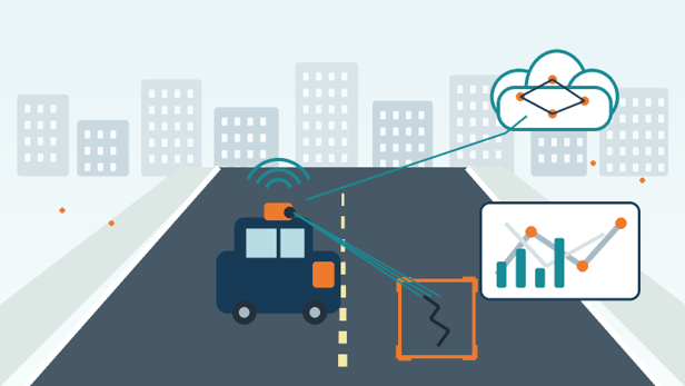
The solution integrates IoT devices installed on urban vehicles, edge processing capabilities, cloud services and AI models. Data collected during the vehicles' normal routes is used to identify possible damage, classify its type, estimate severity and locate it on the road network.
The information feeds into a web platform that provides maps, statistics and indicators on pavement conditions. A decision support system identifies the most critical sections, analyses deterioration trends and sets maintenance intervention priorities.
Project objectives
- Automate the collection and analysis of data on road pavement conditions
- Integrate images, position data and signals from different sensors into a single digital infrastructure
- Distribute processing between edge devices and cloud services, reducing latency and optimising computational resources
- Use Computer Vision and Machine Learning models for damage detection, classification and severity estimation
- Make model results more transparent and interpretable through Explainable AI techniques
- Provide georeferenced tools and decision support functions for maintenance planning
- Validate the solution through prototypes, integration tests and real-world operational trials
A mobile network for road monitoring
In the RENEW framework, vehicles that travel the city daily can become mobile nodes of a detection network. Waste collection vehicles, buses, service vehicles and other urban fleets are equipped with Data Collection Devices featuring RGB cameras, geolocation systems and sensors for dynamic data acquisition.
Using vehicles already operating in the territory makes it possible to integrate monitoring into ordinary activities, increasing observation frequency and reducing the need for dedicated survey campaigns.
From data to decision
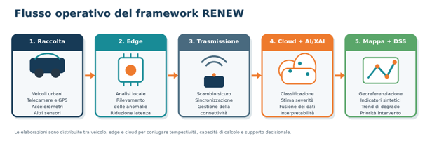
The architecture adopts a distributed edge-cloud model. Initial processing is performed directly on the Data Collection Device to identify images or sequences showing a possible anomaly. Relevant information is then transmitted to the cloud infrastructure, where it is integrated with location data and measurements from other sensors.
In the cloud, AI models classify the type of damage and estimate its severity. Explainable AI techniques highlight the elements that contributed most to the classification. The processed data feeds thematic maps, summary indicators and Decision Support System functions for defining maintenance priorities.
Expected results
RENEW plans to deliver an integrated demonstrator comprising prototype Data Collection Devices, AI models and a software platform for data acquisition, analysis, visualisation and decision-making.
- Prototypes of data collection and processing devices to be installed on selected vehicles
- Edge-cloud infrastructure for distributed management of data and computational workloads
- AI models for pavement damage detection and classification, with over 95% accuracy
- Explainable AI features to support reading and verification of classifications
- Data warehouse synchronised with edge devices, organised for georeferenced data management
- Web application with maps, statistics, historical analysis and network status indicators
- Decision Support System for evaluating criticalities and defining maintenance priorities
- Test and tuning procedures to verify interoperability, security, reliability and real-world operation
Expected benefits
- More timely and objective knowledge of road network conditions
- Early identification of deterioration phenomena and potentially critical situations
- Intervention planning based on up-to-date, measurable and georeferenced data
- More effective use of available economic resources for maintenance
- Reduction of dedicated inspections by using vehicles already operating in the territory
- Greater traceability of assessments and decisions through historical data, indicators and XAI functions
- Ability to replicate and adapt the solution to different cities, road networks and fleets
Partnership
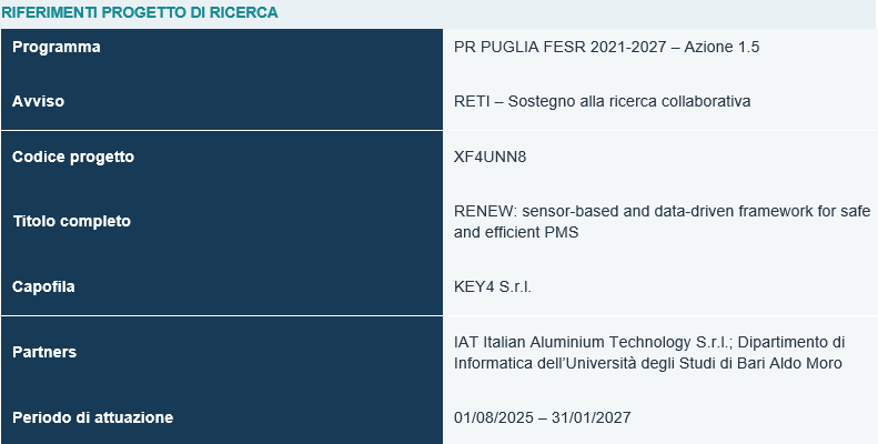
The RENEW project is carried out by a consortium comprising KEY4 S.r.l. (lead), IAT Italian Aluminium Technology S.r.l. and the Department of Computer Science, University of Bari Aldo Moro. The partnership integrates expertise in software design, IoT, AI, hardware prototyping, sensing and academic research.
| Research Project References | |
|---|---|
| Programme | PR PUGLIA ERDF 2021-2027 – Action 1.5 |
| Notice | RETI – Support for collaborative research |
| Project code | XF4UNN8 |
| Full title | RENEW: sensor-based and data-driven framework for safe and efficient PMS |
| Lead | KEY4 S.r.l. |
| Partners | IAT Italian Aluminium Technology S.r.l.; Department of Computer Science, University of Bari Aldo Moro |
| Implementation period | 01/08/2025 – 31/01/2027 |
Project co-funded under PR PUGLIA ERDF 2021-2027 – Action 1.5, RETI Notice – Support for collaborative research. Project code XF4UNN8.

Get in touch
Want to implement RENEW in your municipality or organisation? Contact us for more information.
Request information